

 |
|
|
Thread Tools | Display Modes |
 08-12-2013, 04:42 PM
|
#1 |
|
Senior Member
Join Date: Aug 2011
Posts: 119
Nominated 0 Times in 0 Posts
TOTW/F/M Award(s): 0
|
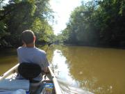
Took a trip from just past the dam to Canoe city yesterday. It was tight in a couple places but passable the whole way. If I remember correctly I think it was about ten miles according to the signs. You could tell where a couple of them were under water recently. Some of the bases/posts still are. But the water was listed at 4.17 foot in Leavittsburg on the USGS site before we left.
What's the normal height in Leavittsburg? The current was slow going. |

|

|
|
«
Previous Thread
|
Next Thread
»
 Linear Mode

|
|
